


lac de la Thuile

laurentnecca
User
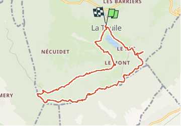

Length
12 km

Max alt
1197 m

Uphill gradient
458 m
Km-Effort
18.1 km

Min alt
874 m

Downhill gradient
462 m
Boucle
Yes
Creation date :
2025-06-17 07:32:25.447
Updated on :
2025-06-17 14:02:13.256
3h48
Difficulty : Medium

FREE GPS app for hiking
 SityTrail
IGN / Geographical institutes
SityTrail Plus
The world is yours!
About
Trail Walking of 12 km to be discovered at Auvergne-Rhône-Alpes, Savoy, La Thuile. This trail is proposed by laurentnecca.
Positioning
Country:
France
Region :
Auvergne-Rhône-Alpes
Department/Province :
Savoy
Municipality :
La Thuile
Location:
Unknown
Start:(Dec)
Start:(UTM)
270038 ; 5046480 (32T) N.
Comments